
Garmin eTrex SE
4.2Editor score
168 hour standard battery life
Multi-GNSS satellite support
Water resistant IPX7 design
Finding reliable navigation is critical for safely trekking the Appalachian Trail. A quality handheld GPS provides precise location tracking, detailed topographic maps, and long battery life essential for remote sections without cell service.
We analyzed ten top-rated GPS models focusing on durability, satellite support, and user experience. Our comparison includes rugged handhelds from Garmin and versatile options suited for through-hikers and casual trail walkers alike.
Each pick highlights unique strengths like extended battery modes, multi-GNSS accuracy, or lightweight designs. Remember that stock and pricing vary over time so verify current availability before making your final purchase decision for the trail.
4.2Editor score

4.6Editor score

4.6Editor score
As an Amazon Associate we earn from qualifying purchases.
Below is a side-by-side overview of all ten featured GPS devices highlighting their key specifications and distinguishing features to simplify your selection process for the trail.
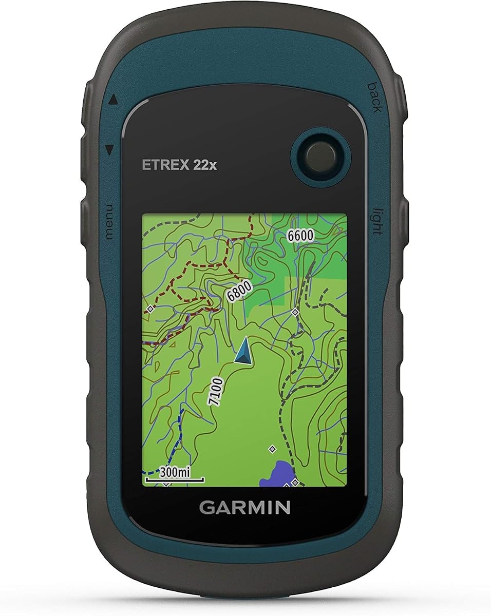





The Garmin eTrex 22x stands out as a dependable GPS tool for Appalachian Trail hikers. It holds a solid rating of 4.3 stars and is praised for its rugged build and consistent satellite tracking.
We may earn a commission when you buy through this link, at no additional cost to you.
This device features a 2.2-inch sunlight-readable color display that ensures visibility even on bright summer days. The inclusion of GPS and GLONASS satellite systems enhances positioning accuracy in dense forests or deep canyons common on the trail.
While it does not have the latest multi-band technology, its 25-hour battery life using standard AA batteries is practical for long stretches between resupply points. The 8 GB internal memory plus micro SD slot allows ample room for detailed map downloads.
Hikers seeking a balance of affordability and performance will find this model ideal. It offers essential navigation features without unnecessary complexity making it a reliable companion for both section hikers and thru-hikers.
Dual GPS and GLONASS support means faster lock-on times and better accuracy in challenging terrain compared to single-system devices.
The micro SD card slot allows you to add custom maps or store extensive trip data without worrying about internal memory limits.
We may earn a commission when you buy through this link, at no additional cost to you.
The Garmin eTrex 32x builds on the 22x foundation by adding a barometric altimeter and 3-axis compass. With a 4.2-star rating it appeals to hikers who need elevation data and precise heading without relying on digital sensors.
We may earn a commission when you buy through this link, at no additional cost to you.
Its 2.2-inch display remains clear and easy to read under direct sunlight. The added sensors help you monitor weather changes and navigate steep ascents common on peaks like Clingmans Dome or Mount Washington where elevation shifts rapidly.
While it shares the same battery life and internal memory as the 22x the extra hardware slightly increases the price. However for those prioritizing precise altitude readings the trade-off is often worth it for safety and route planning.
This model is excellent for hikers who want enhanced navigation tools without switching to a more complex or expensive high-end unit. It provides critical data for weather awareness and orientation on multi-day trips.
Measures altitude pressure to give more accurate elevation readings and help detect approaching storms by tracking pressure trends.
Provides accurate heading information even when the device is stationary or tilted unlike traditional 2-axis compasses that require level positioning.
We may earn a commission when you buy through this link, at no additional cost to you.
The Garmin eTrex SE offers incredible value with up to 168 hours of battery life in standard mode. Rated at 4.2 stars it is designed for hikers who prioritize endurance and reliability over premium features.
We may earn a commission when you buy through this link, at no additional cost to you.
It supports multiple global navigation satellite systems including GPS GLONASS Galileo BeiDou and QZSS. This multi-GNSS capability ensures robust positioning even when the trail passes through deep valleys or dense canopy where single-system devices fail.
The device is water-resistant to IPX7 standards making it suitable for rainy Appalachian days. While it lacks a barometric altimeter its digital compass and smartphone pairing allow for essential trip planning and updates via the Garmin Explore app.
For budget-conscious hikers this model delivers core navigation functionality without breaking the bank. It is an excellent choice for section hikers or those who prefer using detailed maps on a smartphone but need a backup GPS unit.
The long battery life means you can go days or weeks on two AA batteries ideal for remote sections with few charging options.
Accessing multiple satellite constellations improves signal reliability and speed in challenging environments compared to GPS-only receivers.
We may earn a commission when you buy through this link, at no additional cost to you.
This handheld GPS model distinguishes itself with a larger 3.2-inch screen and substantial 32 GB internal memory. Though rated lower at 3.9 stars it offers competitive specs like USB-C charging and extended battery life.
We may earn a commission when you buy through this link, at no additional cost to you.
The bright sunlight-readable display makes it easy to view topographic details and waypoints without squinting. Users appreciate the inclusion of preloaded USA Topo maps which cover many sections of the Appalachian Trail directly out of the box.
Multi-GNSS support ensures accurate tracking while the water-resistant design rated IP66 protects against rain and splashes. The rechargeable battery offers convenience but may not last as long as AA battery models in extreme conditions.
Hikers who prefer larger screens for map viewing and want built-in storage might find this a compelling option. It provides modern connectivity options that some legacy Garmin models lack making it attractive for tech-savvy outdoor enthusiasts.
A bigger screen allows for clearer map details and easier touch or button navigation especially for users with vision challenges or gloves.
Standard USB-C charging simplifies power management on the trail allowing you to use the same cable as many modern smartphones.
We may earn a commission when you buy through this link, at no additional cost to you.
The Garmin GPSMAP 65s represents the top tier of handheld GPS devices with multi-band technology and a 2.6-inch color display. It boasts a high 4.6-star rating reflecting its reliability and advanced feature set for serious hikers.
We may earn a commission when you buy through this link, at no additional cost to you.
Multi-band technology enables optimal accuracy in challenging locations such as dense forests or urban canyons where signal reflection typically degrades performance. The expanded satellite support ensures you maintain a lock even in difficult terrain.
With a 3-axis compass and barometric altimeter you gain critical data for elevation changes and weather trends. The device integrates well with the Garmin Explore ecosystem allowing for seamless route planning and stats review from your smartphone.
While it carries a premium price this model is worth the investment for those who demand the highest navigation precision. It is ideal for hikers undertaking technical routes or those who need robust tools for safety on long expeditions.
Uses multiple frequency bands to reduce signal interference and provide more accurate positioning in environments with tree cover or tall structures.
Wireless connectivity lets you sync tracks routes and waypoints with the Garmin Explore app making it easy to update plans between trips.
We may earn a commission when you buy through this link, at no additional cost to you.
While not a GPS this book is an invaluable reference for planning your Appalachian Trail journey. With a 4.8-star rating it provides official maps and rich historical content to complement your digital navigation tools.
We may earn a commission when you buy through this link, at no additional cost to you.
Inside you will find a removable full-size copy of the National Park Service map of the entire trail. This physical map offers a comprehensive overview that helps in overall route planning and understanding the trail geography.
The book includes over 300 contemporary images and unpublished historical photos from ATC archives. These visuals and essays offer inspiration and context about the trail history and significance before you even step on the path.
This book is perfect for pre-trip preparation and for preserving memories of your hike. While it cannot replace a GPS for on-trail navigation it serves as an essential companion for understanding the trail legacy and planning your adventure.
The included full-size map provides a complete view of the 2100-mile route ideal for planning sections and identifying resupply towns.
Understanding the history of the trail can deepen your appreciation for the path and prepare you for the community you will meet.
We may earn a commission when you buy through this link, at no additional cost to you.
The Garmin Foretrex 401 offers a unique wearable design that clips to your wrist freeing your hands for trekking poles. It holds a strong 4.6-star rating for its compact size and reliable GPS performance.
We may earn a commission when you buy through this link, at no additional cost to you.
HotFix satellite prediction improves performance in heavy tree cover or deep canyons where signals might be weak. The TracBack feature is particularly useful for retracing your path if you need to return to your starting point quickly.
Although the display is small it provides essential data like distance and coordinates clearly. The device uses standard AAA batteries and stores up to 10000 track log points allowing you to capture detailed routes over time.
Hikers who prefer minimal gear and want a secondary GPS backup will appreciate this model. It is less cumbersome than a handheld and ensures you always have basic navigation available without needing to pull out a device.
The wrist-worn design allows you to glance at your position without stopping to handle a handheld device or phone.
Retraces your exact path automatically which is invaluable if you take a wrong turn or need to return from a summit quickly.
We may earn a commission when you buy through this link, at no additional cost to you.
The Garmin eTrex 20x is a classic rugged handheld that offers enhanced memory and resolution for its time. Rated 4.3 stars it remains a solid option for hikers wanting reliable navigation with proven durability.
We may earn a commission when you buy through this link, at no additional cost to you.
Its WAAS-enabled GPS receiver allows for precise positioning using satellite corrections. Combined with GLONASS support it ensures you get a quick fix and maintain it even in challenging environments like deep valleys or dense forests.
The 2.2-inch color display offers better resolution than earlier models allowing clearer map viewing. With 3.7 GB of internal memory you can load various map types including Topo and satellite imagery for detailed route planning.
While newer models offer more features this unit delivers core navigation at a reasonable price. It is a good choice for hikers who prefer a simple no-nonsense device with a trusted brand reputation for reliability on the trail.
Wide Area Augmentation System improves accuracy to within a few meters ensuring precise navigation in all conditions.
Ability to load different map types lets you customize your device with topographic satellite or city maps as needed for your journey.
We may earn a commission when you buy through this link, at no additional cost to you.
This book tells the inspiring story of Emma Gatewood who hiked the Appalachian Trail in 1955. With a 4.6-star rating it offers motivation and historical perspective for anyone dreaming of walking the trail.
We may earn a commission when you buy through this link, at no additional cost to you.
The author interviewed surviving family members and unearthed historic articles and Gatewood's diaries. This research provides a detailed look at her journey and the impact she had on the trail maintenance and public awareness.
Gatewood's story highlights resilience and determination which are valuable traits for any long-distance hiker. Her trail experience led to improvements that benefited those who followed making this a legacy of the trail itself.
Reading this book can provide mental preparation for the challenges of long-distance hiking. While not a technical guide it offers the inspiration needed to take on the adventure and appreciate the trail community.
Grandma Gatewood's advocacy helped preserve the trail leading to better conditions for modern hikers and establishing a strong trail culture.
Her story of leaving at age 67 reminds us that age is not a barrier to achieving great outdoor adventures.
We may earn a commission when you buy through this link, at no additional cost to you.
This guide covers the best outdoor experiences across six northeast states including sections of the Appalachian Trail. It holds a 4.5-star rating and features 101 detailed maps and stunning color photographs to help plan your adventure.
We may earn a commission when you buy through this link, at no additional cost to you.
Many Appalachian Trail sections run through these northeastern states making this book a valuable resource for planning those specific portions. The expert guidance helps both novice and experienced hikers identify scenic locations and safe routes.
Using this guide before your main trip can help you practice navigation and get familiar with the terrain. The high-quality photos also provide a visual preview of what to expect on the trail enhancing your preparation.
While it does not cover the entire trail it offers excellent depth for the northeastern segment. Hikers starting or ending their thru-hike in this region will find this book particularly useful for mapping out side trips and campsites.
The detailed maps and photos provide precise information on terrain and landmarks that general AT guides may not cover in depth.
Using these trails for shorter hikes can help build stamina and navigation skills before committing to a long-distance Appalachian journey.
We may earn a commission when you buy through this link, at no additional cost to you.
Selecting the right GPS device depends on your specific needs, budget, and how much you value features like battery life, map detail, and durability on the trail.
Long battery life is crucial for multi-day hikes where charging options are scarce. Look for devices that support standard AA batteries or offer extended expedition modes to ensure navigation remains available between resupply points.
Prioritize models with at least 25 hours of life to avoid unexpected power loss during remote sections of the trail.
A sunlight-readable screen ensures you can read maps without removing your gloves or stopping in bright conditions. Color displays offer better detail than monochrome ones and are easier to interpret quickly while hiking.
Choose a display size that balances readability with device weight to keep your pack comfortable over long distances.
Multi-GNSS support including GPS GLONASS and Galileo provides better positioning in areas with dense tree cover or deep valleys. Dual or multi-satellite systems reduce lock-on times and improve accuracy.
Verify the device supports multiple systems to ensure consistent tracking throughout diverse Appalachian Trail terrain.
Hiking in the Appalachians involves exposure to rain and rugged terrain so water resistance is essential. Look for IP ratings like IPX7 or IP66 to ensure the device can handle splashes and submersion.
A rugged design with physical buttons also improves usability when your hands are wet or gloved.
Preloaded topographic maps save time and storage space compared to manually downloading maps. Check if the device comes with official trail maps or if you need to purchase them separately.
The ability to expand storage with a microSD card allows you to carry multiple map sets for different regions.
Lighter devices reduce pack weight which is significant on long-distance hikes. Handhelds are bulkier than wearable wrist units but often offer better battery life and display sizes.
Consider how the device fits in your pocket or pack and whether you prefer a handheld or wearable form factor.
Devices that sync with smartphone apps allow you to upload routes and view stats easily. Wireless updates ensure your maps and software remain current without needing a computer connection.
Connectivity features enhance planning and data sharing but may add complexity to the device.
GPS prices vary based on features and brand. Determine which features are essential for your trip and avoid paying for unnecessary premium functions you won't use.
Balance cost with reliability to ensure you get a device that performs well without overspending on extra capabilities.
Charge your device fully before starting your hike and ensure you have extra batteries or a power bank for long trips. Check the satellite connection in an open area before heading into the woods to confirm functionality.
Familiarize yourself with the interface by reading the manual and practicing on local trails. Mark your starting point and waypoints regularly to create a trail log that helps with navigation and rescue efforts.
Keep the device dry and stored in a protective case when not in use. Clean the screen and buttons gently with a soft cloth to maintain responsiveness and prevent debris from affecting performance.
While not strictly required, a GPS provides reliable navigation in areas where phone signals fail or maps are unclear. It is highly recommended for safety and peace of mind on long or remote sections.
For multi-day trips, look for a device with at least 25 hours of battery life. Many hikers prefer models with AA batteries so they can carry spares easily in their packs.
Smartphones are convenient but batteries drain quickly and screens are hard to read in sunlight. Dedicated GPS units offer longer life and better durability making them ideal as a primary or backup tool.
Yes, most handheld GPS devices support microSD cards or internal storage for offline maps. You can load topographic maps to navigate without needing cellular service.
Garmin is the leading brand offering a wide range of reliable models with good support. Their devices are known for durability and extensive map options suitable for the Appalachian Trail.
Use a waterproof case or pouch even if the device is water-resistant. Avoid exposing it to heavy rain for long periods and dry it off after exposure to moisture.
The Garmin eTrex 22x, GPSMAP 65s, and Foretrex 401 stand out as top choices for reliability and features. Each offers unique benefits suited to different hiking styles and budget constraints.
Prioritize battery life, display clarity, and satellite support to ensure consistent navigation. A well-chosen GPS will enhance your safety and enjoyment on the trail.
Remember to check current pricing and availability before purchasing. Prices fluctuate and stock may vary so verify the details before finalizing your order.